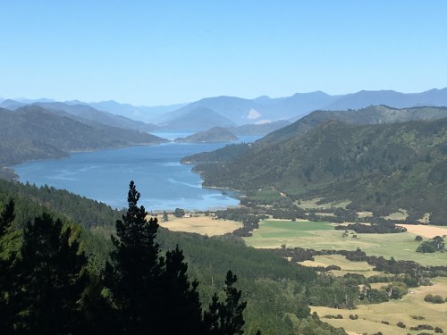
Bay of Many Coves
The words ‘multi-day hike’ and ‘luxurious’ might seem an unlikely combination, unless you are referring to the Queen Charlotte Track.
You can do it the hard way, lugging everything you need and staying in camping grounds, or you can arrange things so your baggage travels by water taxi each day and arrives well before you do at a resort featuring comfy beds, hot showers, a licensed restaurant and maybe even a hot spa to ease those aching legs. All you need to carry is a daypack containing water, lunch, camera and wet weather gear to ward off rain.
The 71 km walk is in the Marlborough Sounds, on the north-eastern top of the South Island of New Zealand. From the township of Picton you travel by boat for an hour to the far end of Queen Charlotte Sound, in order to spend four days walking back.
Spectacular views from the ridges reward you for trudging (repeatedly) up up up (usually to an elevation of about 400 m) and down down down (to sea level, of course). The track is well formed and often shady and soft underfoot, decorated with tree ferns, mossy rocks, waterfalls and the occasional curious weka (a native bird).
If you are blessed with fine weather, as we were, it’s beautiful experience. If the sea and sky were grey, and the views obscured by rain clouds, I expect the long days of walking might not be so enjoyable. Because although the track is graded easy/intermediate, two of the four days involve walking 20 km+ over 6-8 hours. As indicated earlier, it’s not ‘mostly flat’ walking where you can power along at 5-6 km/hr. You could say some of it is ‘undulating’, but there’s no shortage of ‘steep’ either. Generally we (three women of average fitness in our 50s) were close to the times on the signs, trundling along at about 3-4 km/hr. So we certainly appreciated a little bit of luxury at the end of each afternoon!
Day 1: Picton – Furneaux Lodge
The morning was bright blue with touches of early mist when our trip organiser, Greg from Natural Encounters, delivered us to Picton wharf for our 8 am water taxi. A gorgeous late February day, heading for a high of 23 degrees with no rain forecast.
We landed first at Motuara Island, a bird sanctuary that has been cleared of predators. We walked 1.5 km (half an hour) solidly uphill to the lookout, and while there were many twitterings in the trees, we saw most of the birds at a little waterhole near a seat five minutes from the jetty. But at least we’d warned our going uphill muscles what was in store for them.
From there it was a short hop across to Ship Cove, a spot beloved by Captain James Cook, who dropped in frequently. We dutifully viewed the monument and read the signage, then began the day’s walk at 10.45 am, arriving at our destination, Furneaux Lodge, six hours later.

Wendy, Libby and Janene at the start of the 71km hike
The track began with a 50 minute slog uphill to an elevation of about 250 m, then a corresponding downhill back to sea level, so the first four or five kilometres took a couple of hours. When we stopped for lunch at a beach called Schoolhouse Bay (only a 500 m detour) we were hot and ready for a rest. Libby stripped off to swim; I removed boots and socks to wade, having decided the 15 degree water temperature wasn’t tempting enough. We were glad to sprawl on the grass and eat our lunches, but we had to watch out for numerous bees feasting on the ground alongside us.
After lunch there was a fair bit of up and down until the final gentle stretch that felt like it was stretching on forever because my FitBit was lying to me. But it was lovely walking among the tree ferns along soft, leaf-strewn shady paths, climbing occasionally above the foliage for stunning views of sea, land and sky.
Along this section, we kept seeing ingenious looking traps for catching stoats and rats, as the Department of Conservation was trying to make that arm of the peninsula predator free. Libby, who is a vet, was fascinated by the white cylinder that released some kind of gas – we were told later that it was pressurised with carbon dioxide that triggered a guillotine, so the dead animal fell out and the trap automatically reset itself. DOCs must be just tidying up the last few remaining predators as we didn’t see any headless corpses lying about.
Our tally for today was 18.5 km (14.5 km for the main part of the walk, plus 3 km on the island and 1 km for a lunch spot detour). Unfortunately, unbeknowest to me my FitBit Charge was clocking up extra kilometres, because my step length was set for my usual brisk walking pace rather than for hiking. As the afternoon wore on, this made me believe we must be closer than we actually were to the end of the walk. It was quite dismaying when cheery harbingers, people doing short walks along the track from the opposite direction, kept appearing to tell us not far now, only another hour, or another half hour, when I thought we must be only minutes away.
Finally walking into the grounds of Furneaux Lodge, a long, low historic white house with grounds extending to the water, felt absolutely marvellous. We fell into bed straight after dinner, so it was a pity (digestion-wise) that I’d eaten a dessert I didn’t need (citrus tart & icecream) after my delicious fish fillet on risotto with garlic prawns and vegetables.

Furneaux Lodge
Day 2: Furneaux Lodge to Punga Cove Resort
This was our easy day, an 11.5 km mostly flat (the NZ version of mostly flat) stroll around the bays. We didn’t leave until 10 am, after lingering on the terrace with our coffees.
Today my boots and walking pole went by water taxi in my luggage. I felt more normal in joggers, with both arms swinging freely.
We did the walk in exactly the average time, arriving at 2:30 pm despite Libby leaving her glasses behind at a stop and having to go back for them, and despite me having a copious nose bleed just as we reached Camp Cove. Fortunately there was a toilet block there with extra paper and a sink. No idea what brought it on, unless I was overheated by a steepish full-sun section.
It was about 24 degrees today and we felt hot when we arrived at Punga Cove Resort, so Libby and I went swimming almost immediately. Once you were numb you didn’t notice how cold the water was. It was ‘refreshing’, and you did sort of get used to it, but we didn’t linger long.
Afterwards, we ate the cake we’d saved from our lunches, and some of my Lindt chocolate, sitting in the warm sun on our deck, which had gorgeous views of vivid blue and verdant green.

Looking towards Punga Cove Resort from the track
I decided to try the hot tub, hoping it might help my knees, which had been fine today walking on the level but tender on the uphills. The tub wasn’t large, and two men were in it already, so I sunbaked nearby, hoping they would leave. One eventually did, and I joined the other one and heard his tale of doing three hikes over two weeks with his friend’s bushwalking club from Brisbane. He led into this topic by asking ‘how many walks are you doing while you’re in NZ’? They were on their third. He said the members of his friend’s club walked regularly throughout the year, but he didn’t, and so he found these intensive trips quite taxing. Also he was ‘carrying some injuries’ such as as the swollen ankle that he popped above the water to show me and a sore back that had been going into spasms.
But he was still not planning to take the water taxi option tomorrow. His plan was to recuperate by spending maximum time in the spa, and to rise by daybreak and leave before the others in his group so he wouldn’t hold them up. Unlike us, they had a 4.30 pm deadline for a boat to Lochmara.
There was no way I’d be trying tomorrow’s 24 km with all its steep ups and downs with an ankle like that and a crippling back – it made me wince just to think of it. I could only put his stoicism down to machismo. I said that I hoped when we saw him on the trail tomorrow he wouldn’t be the one being stretchered out. But we didn’t see him, so maybe he changed his mind about the water taxi, or else he managed to keep in front of us the whole way.
Dinner was tasty, tender Angus beef fillets on mash with vegetables, followed by a trifle with not enough brandy in the custard. I managed to collect a few sandfly bites but an antihistamine tablet stopped them from turning into their usual itchy welts. We had no alcohol, and we were in bed by 10 pm so we could be up early tomorrow for the day billed as ‘the most arduous’.

Dinner with a view – and a few sandflies
Day 3: Punga Cove Resort to the Portage Resort Hotel
Today we were out the door before 7:30 am. I wore my boots and took the hiking pole, but mostly that stayed stowed on my pack. I find the rhythm of walking much more natural without it. Might be different if I had two of them. I didn’t carry my raincoat, though, as another warm blue day was forecast and I begrudged the extra weight. Took 2.5 litres of water, which was spot on, as by the end I only had 250 ml left over.
It was great to have left so early, while it was still cool, as the first long steep section was an exposed white gravel track. But for much of the day we were either on the shady side of a mountain or enclosed by ferny, mossy greenery, and in the more open spots there was a brisk cool breeze that would have been strong enough to blow our hats off if we hadn’t had strings to hold them on. Of course the highest bits came with stunning views. It really is a lovely walk.
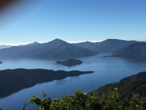
View into Kenepuru Sound
We passed and were passed by several groups we’d met on previous days, including a middle-aged woman who’d sent her parents by sea today, and a cycling couple who had walked the first two days. They were at the Portage for dinner and had taken 7 hours compared to our 8.5 hours, so not much gain with wheels instead of legs, and they said the occasional juddery rocky surfaces and pushing the bikes up the steep hills hadn’t been much fun.
We skipped the 1.5 km 30 minute detour up to Eatwell’s Lookout (the length/difficulty of today’s walk was already intimidating) and were told later that the 360 degree views from this highest point (484 m) were spectacular but the track up was particularly steep. We had views aplenty but later I regretted not having made the effort to reach this lookout, as none of the others were all round in every direction like this was supposed to be.
We powered along well for the first section. The second third dragged a bit with a paucity of stopping spots, and the final two hours were the worst – not because of the terrain, which finally settled into a pleasant slow descent in beech forest, but because our feet and legs had had enough. As the gradient map shows, there were many PUDs today, pointless ups and downs, and the downs were definitely harder on the knees and toes (your feet are forced to the front of your boot). Libby tried walking backwards occasionally, to ‘unlock’ her knees, and was pleased to see someone else doing that too. Her strategy was to keep her walking style the same on the downhills, but my variation was a slightly faster (sort of shambling) pace on the steepest sections.
Emerging from the track onto the road down to Portage Bay we collapsed on the grass next to a sign saying it was 15 minutes to the resort, and ate the last of my chocolate, which surprisingly hadn’t melted in my pack.
Dinner was mediocre – I had Canterbury Lamb, which managed to be dry, and it came with a decorative (i.e. insufficient) quantity of vegetables. But our after-dinner sunset was just perfect …

Sunset from the Portage Bay Resort Hotel
Day 4: Portage Resort Hotel to Anakiwa
I was unimpressed by Portage Bay Resort (there’s a review on TripAdvisor) and wished we’d gone to Lochmara Lodge instead, where I expect our rest day would have been more interesting and more enjoyable. However, the main problem was that when we fronted reception to check out this morning we found no packed lunch had been prepared for us. The delay jangled our nerves (we had 21 km to walk and a boat to catch) but in the end we had plenty of time. Nonetheless, I think Portage Resort would be well advised to overhaul its bureaucratic and customer-unfriendly business processes.
We were at the start of the track by 8.20 am, ready for the steep uphill slog, hoping the lift we’d received had saved us some of the first hour’s climb. Half an hour of ascent gave us great views and it looked like the top, but it wasn’t. It was a full hour to the Shamrock Ridge sign saying 407 m elevation, the highest point for today, with views across both Kenepuru Sound and Queen Charlotte Sound.
View from Shamrock Ridge across Queen Charlotte Sound
A party of lean, fit women overtook us here and the last of their number was carefully coiffed blonde who was blaring pop music as she walked along. I tried to get far enough in front of her so the auditory pollution wasn’t annoying me but she caught up when I stopped to take a photo, so I decided to let her get well ahead instead. I felt a bit incredulous that someone would think this was okay behaviour on an otherwise peaceful bushwalk, and not think to use ear buds.
The steep up to Shamrock Ridge was followed by an equally steep down, as shown on the gradient map that Wendy and I had studied beforehand (Libby deliberately chose not to look at them, preferring to take it as it came). We felt a little pressured about keeping up a good pace and minimising our stops as all the information about the walk said it took eight hours to do the 21 km but we only had seven hours before the boat left at 3.30 pm. But everyone had assured us no one ever missed the ferry.
Once we’d done the hardest section, 7.5 km that was allocated 4 hours, in 3.5 hours, I felt we were going to be fine even though another 12.5 km remained. We ate lunch just before midday, feeling footsore and tired and sitting right beside the track in the shade, with our backs against a grassy bank and our socked feet resting on our boots instead of in them. Despite being a bit soggy, and being made of white bread, the sandwiches were delicious. While walking I didn’t feel hungry, but once I sat down to eat I relished my food.
From then it was a slog to Davies Bay, where Libby and I planned to swim if we had time as from there it was only another three km on the flat. On this stretch we decided that on future walking holidays, we’d prefer a daily maximum of 15 km. These 20 km+ stretches made our 50+ year old legs and feet hurt. I popped a couple of panadol to stop their pointless complaining.
Although it was still varied, more of today’s track seemed to be grassy or overlooking farmland – we were getting closer to civilisation, I suppose. There seemed to be more casual or day hikers on this portion of the track, and more cyclists as well. We had been surprised to learn (on the boat the first day) that most of the beautiful forest sections were second generation, growing since the 1950s, because prior to that the goal had been to cut everything down for sheep grazing. This had proved disappointing as the soil didn’t stay fertile for long then began to erode and wash into the sounds. The boat skipper also talked about the dead trees we could see on some hillsides – there’s a campaign to get rid of the pines as they inhibit the native regrowth and don’t provide habitat for native birds. But it’s a big job – they can’t simply spray indiscriminately – they are having to inject individual trees with poison in rugged terrain.
We got to Davies Bay in plenty of time, by 1:45 pm, so we had a good half hour there before the last bit. A chatty woman with curly grey hair and an Indigenous Australian accent accosted us asking if the spray of red berries she was holding were edible. We said we didn’t know and she said her policy was to eat a few on one day and if they hadn’t killed her by the next day to eat some more. I made a dash for the toilets, which were three hours apart today, too far for my busy bladder, and there’d been a shortage of discreet off-track options.
When I returned, Libby was already in the water, wearing her swimmers, but I didn’t have mine and had decided my special black quick drying tshirt and my firm-fitting brightly coloured undies would suffice. Wendy sat in the shade – she likes warm water not this freezing stuff New Zealand produces. I waded out still wearing my glasses and did a nanna swim, just enough to cool down. Libby said she had seen a stingray so I thought of Steve Irwin and didn’t hang about.
We made it it Anakiwa with another half hour to spare, so it was really a six hour walk including lunch break. Maybe they inflated the time estimates to make sure you don’t miss the boat. We felt pretty pleased with our bodies – 71 km in four days and we were still on our feet sporting nothing worse than a few sandfly bites and blisters. I didn’t even have blisters, thanks to the lovely wide toe box on my Keens hiking boots.
The famous trailer-cafe at the end of the track was open and ready to sell us drinks and ice creams. I even managed to get a celebratory affogato!

Made it!


")


")

")